

Navigation in Low Visibility
As the fog descends, the 360-degree view from the Air Traffic Control (ATC) towers fades and pilots vision is challenged with Cockpit view disappearing. To their aids comes the electronic aids to maintain safe and efficient flow of traffic. Landing a plane in foggy conditions is perfectly possible with the airports help of an ILS, which guides planes down to the tarmac using radio signals.

Managing Low Visibility Winters in the capital bring a gift of fog and disrupts the flight schedules. Foggy conditions prevailing in the northern part of India, pose grave challenges for aircraft movement at an operational level.
AAI is all out to tackle the issue of fog with the best landing system and there by significantly reducing diversions and delays caused due to low visibility.
It takes huge competences of operational readiness, emergency preparedness and crises response to deal with fog effectively and to manage air traffic efficiently during excessive fog conditions, Low Visibility Procedures are administered to reduce the amount of delay, minimizing the airborne holding and fuel burn.
AIRPORT OPERATIONS - LVTO
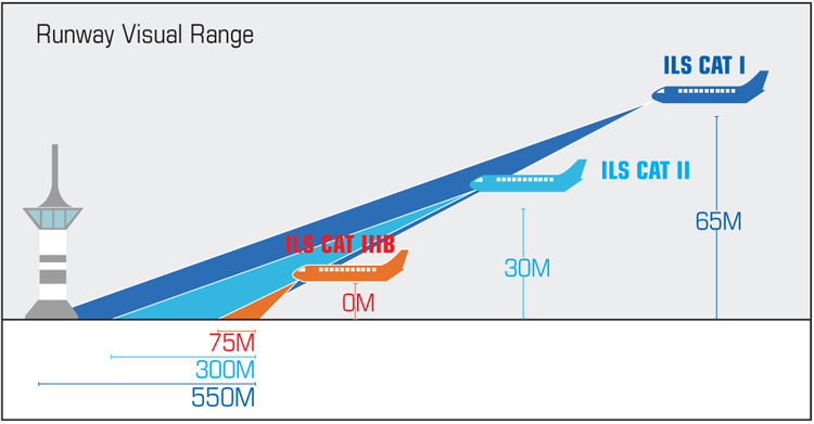
| Type of ILS Operation | Runway Visual Range Minima (in meters) |
| CAT- I | 550 |
| CAT- II | 300 |
| CAT- IIIA | 175 |
| CAT- IIIB | 50 |
| CAT- IIIC | 0 |
Low Visibility Procedures are specific measures taken at an aerodrome to ensure safe operations during Category (CAT) II/III approaches and low visibility take-offs. Five airports in India - Delhi, Kolkata, Lucknow, Jaipur, and Amritsar are equipped with CAT IIIB Instrument Landing System (ILS), which enables the aircraft to land when the visibility is down to 50 metres.
ILS is a standard International Civil Aviation Organisation (ICAO) precision landing aid that is used to provide accurate azimuth and descent guidance signals to aircraft for landing on the runway under normal or adverse weather conditions. It is an accurate and dependable means of navigating to the runway in Instrument Flight Rules (IFR) conditions. The ILS provides the lateral and vertical guidance necessary to fly a precision approach.
The Airports Authority of India (AAI) has also formulated Low Visibility Procedure for Take-Off (LVTO) when the Runway Visual Range (RVR) falls below 400 metres. In the national capital, the aircraft can take off up to a minimum RVR of 75 metres. LVTO has been formulated and established by AAI for airports like Patna, Ahmedabad, Bengaluru, Guwahati and Varanasi, where there is no CAT-II and CAT-III operations. This procedure is of much help in enabling airline operators to enhance on-time performance.
THE MECHANISM
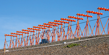
For any low visibility operation, it is important for an airport to be qualified, an aircraft to be certified and the pilots to be CAT-III rated. An airport should also be equipped with HIAL- high intensity airfield lights to locate runway and taxiways, ILS and RVR system to provide the latest visibility on runway and surface movement radar for monitoring and controlling ground movement.
The 360-degree view from the Air Traffic Control (ATC) towers fades as the fog descends, forcing controllers to use electronic aids, such as surface movement radar and switch to ‘low visibility procedures’ to maintain safe and efficient flow of traffic. For pilots, when Cockpit view disappears, they purely rely on instruments and aids for landings and take offs. Although difficult, landing a plane in foggy conditions is perfectly possible with the airports help of an ILS, which guides planes down to the tarmac using radio signals.
RUNWAY VISUAL RANGE
There are various categories of ILS, which aid the pilots’ descent up to touch down. The different categories of ILS and the operating minimum RVR for each category is given in the table below:
The time between aircraft landing increases by up to 50 per cent. Increasing the time between arrivals decreases the number of aircraft that can land during fog. This further decreases capacity and leads to delays, which can build very rapidly, which often result in diversions. The airfields taking diverted traffic could then also become subject to delays because of the extra traffic.
ILS - STRUCTURE
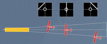
Localiser. The localiser is a radio transmitter that communicates with the aircraft to provide horizontal guidance and tells the pilot if they are left or right of the runway centreline and aligns it with the runway.
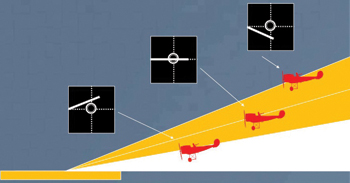
Glideslope. The glideslope provides the vertical guidance and tells the pilot if they are high or low and helps them in descending at the correct rate.
Glidepath Antenna. The glidepath antenna is located adjacent to runway (directly opposite the touchdown location), approximately 340 metres from the start of the runway. The glidepath antenna emits two Ultra High Frequency (UHF) beams to a distance of 10 nautical miles. The UHF beams provide a lower and upper range of slope upon which the aircraft is to track to enable it to land at the required touchdown location on the runway.
Localiser Antenna. The localiser antenna is located on the extended runway centreline approximately 300 metres beyond the runway end that indicate the direction of the runway. It emits a Very High Frequency (VHF) beam to a distance of 25 nautical miles that align the aircraft to the centreline of the runway commencing from a distance between 8 and 12 nautical miles from the start of the runway.
ILS - ADVANTAGES
Continuity of flight operations does not get hampered during foggy weather with the use of ILS and LVTO. The risk of inadvertent runway incursion gets reduced to a great extent both by aircraft and vehicles in the operational area by the implementation of suitable safeguarding procedures during low visibility operations. Passenger inconvenience gets minimised due to less or no change in flight movements as the congestion in airspace/at airports is reduced to a significant extent due to on-time flight movements. To add, diversions and delays, which leads to fuel burning and carbon emission, reduce by a significant extent.
SP's AirBuz - CURRENT ISSUE