

GAGAN: India's First Step to a Future Air Navigation System
By Vasuki Prasad with Inputs from C.R. Sudhir, General Manager (CNS) heading the Ground-Based Elements of the GAGAN Project at Bengaluru
The Navstar Global Positioning System, called GPS, is a space-based radio navigation system operated by the US Air Force (USAF). With a constellation of 24-32 satellites in six orbits around the earth, users the world over receive signals from a minimum of four satellites to determine position. Due to its global availability, the Navstar GPS is designated as a Global Navigation Satellite System (GNSS). Intended for military use, the first GPS satellite was launched in 1978.
In 1993, nearly 20 years after GPS was conceptualised at the Pentagon, the US Department of Defense made this service available for civilian use free of charge as a standard positioning service (SPS). Operating on L1 band at 1575.42 MHz with 100 metres accuracy, SPS is monitored by the Federal Aviation Administration. Another service, the precise positioning service (PPS) with accuracy of under 22 metres, was for the US military.
Although accurate, there is no guarantee that the source of information is error-free. In July 2001, a faulty clock on one of the satellites introduced errors in positioning of 2,000-3,000 km lasting for 90 minutes. Based on information from satellites, receivers determined the position as accurate, but faulty information led to error in computation of position. Positional information integrity during a precision instrument approach, the most critical phase of flight, could thus be a problem.
Accuracy and Trust Issues
GNSS receivers determine their position through “pseudo ranging”, using signals from one satellite as reference against which signals from three other satellites are compared to compute time delays which correspond to distance from satellites. The position of each satellite is contained in the satellite signal broadcasts. A minimum of four satellites are required to determine position. If signals from a fifth satellite are received, the receiver can use the data from a combination of four satellites and compute five positions. If one of the positions disagree with the other four, the receiver detects a fault the source of which it is unable to pinpoint. With the help of signals from a sixth satellite, the faulty satellite can be identified, isolated and its signals not used for computing position. Through this method, known as Receiver Autonomous Integrity Monitoring or RAIM, the receiver is able to deduce the integrity of the computed positional accuracy. Greater the number of satellites, better is the integrity of positional accuracy. This feature is mandatory on certified airborne GNSS receivers.
However, the RAIM algorithm, which facilitates positional integrity, needs a minimum of six satellites and it may take up to six hours for the USAF to disable signal from a satellite with an erroneous clock. The worst case scenario is if three or more of the six satellites develop faults. The RAIM algorithm cannot cope with these situations which may provide misleading information. Hence aviation GPS receivers, all of which must check for RAIM, may be used only for supplemental, not primary navigation.
Monitoring and Correcting
If accurately surveyed GNSS monitoring stations on the ground receive GPS signals, compare the received data with the expected data based on their fixed, surveyed position, the error can be computed. If this error is uplinked to geostationary satellites, which then broadcast to all GNSS receivers in the area, the GNSS receiver can apply the necessary corrections for greater accuracy as well as obtain additional data regarding a satellite’s health, allowing for higher levels of integrity. Such a system is known as a Satellite Based Augmentation System (SBAS).
An SBAS augments existing GNS system over an area as wide as covered by ground monitoring stations. SBAS presently operational are Wide Area Augmentation System (WAAS)-USA, European Geostationary Navigation Overlay Service (EGNOS) and the Japanese Multi-functional Satellite Augmentation System (MSAS). The Indian GPS-Aided Geo Augmented Navigation (GAGAN) is the fourth and latest SBAS to become operational. All four SBAS augment the Navstar GPS.
Indian GAGAN System
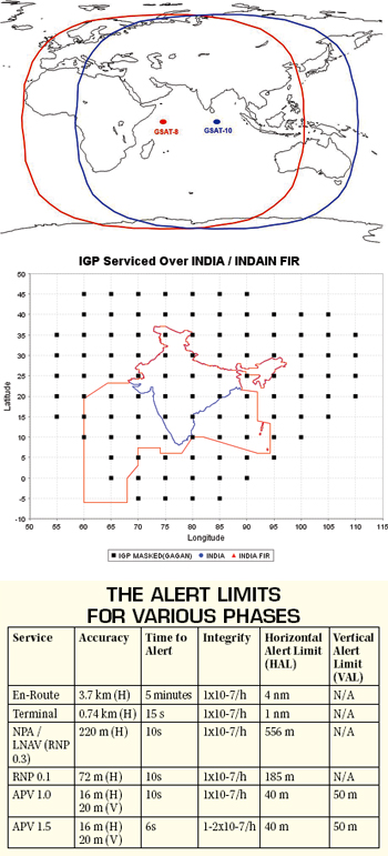
There are two important sources of GNSS derived position errors, satellite errors and signal propagation delays. Satellite errors such as clock and positional errors apply to users irrespective of location. Such errors if corrected, improve receiver accuracy. Signal delays are specific to user location based on the conditions prevailing in the ionosphere through which the satellite signals must pass. It is necessary for a user to correct these errors to further improve positional accuracy. Correcting for location-specific ionosphereinduced signal propagation delays is challenging. To overcome this, the ionosphere is mapped onto multiple ionospheric grids each measuring 5° x 5°. The degrees correspond to the latitudes and longitudes over which the ionosphere is present. The corners of these grids are termed “Ionospheric Grid Points (IGP).” Ionospheric delays will be estimated for each of these IGPs by installing precisely surveyed reference stations at strategic locations.
Raytheon’s Satellite Air Navigation System marks 10 years of continuous service in the US
The system augments GPS signal for safe, reliable and accurate air navigation
The US Federal Aviation Administration’s satellite-based Air Navigation System, developed by Raytheon, marks 10 years of continuous operation in the United States this year. The wide area augmentation system (WAAS) was officially commissioned by the FAA for public aviation use in July 2003, and since then has continuously transmitted an enhanced and 100 per cent reliable global positioning system (GPS) satellite signal that meets air navigation performance requirements for en route, terminal, non-precision approach and precision approach phases of flight. “WAAS has met or exceeded all of its signal in space requirements for more than a decade without disruption,” said Joseph Paone, Director of Raytheon’s Air Traffic Systems. “Pilots are now enjoying all-weather access to thousands of airports.”
With the certification of WAAS, the FAA became the first air navigation service provider in the world to make precision navigation signals via satellite available for aircraft use.
WAAS uses ground-based facilities to monitor and correct conventional GPS signals before diverting them to WAAS-capable satellite navigation receivers in aircraft. This provides safe and precise horizontal and vertical approach guidance to all runway ends without any ground equipment at the airport WAAS supplies reliable, all-altitude navigation signals, even in remote and mountainous areas. It also saves jet fuel and reduces noise and emissions by helping aircraft achieve the ideal glide path as they approach landing with little need for engine thrusting.
Raytheon is the world’s leading provider of satellite-based augmentation technology. In addition to the US WAAS programme, the company’s technology is used on the Japanese Multi-Functional Transport Satellite system as well and on India’s GPS-Aided Geo-Augmented Navigation System (GAGAN), which is scheduled to go into operation later this year. A global leader in air traffic management, Raytheon has 60 years of experience providing solutions for civil and military customers in more than 60 countries covering 60 per cent of the world’s airspace. The company is committed to supporting safety, efficiency, reduced environmental impact and enhanced security in the world’s airspace by providing the industry’s most innovative and comprehensive portfolio of proven air-traffic management solutions.
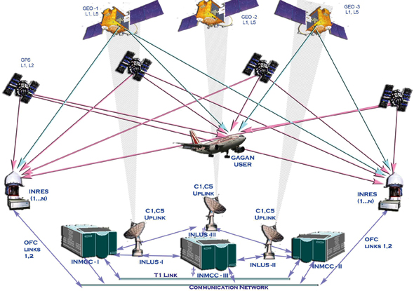
In the GAGAN system, developed jointly by the Airports Authority of India (AAI) and Indian Space Research Organisation (ISRO), Indian Navigation Reference Earth Stations (INRES) have been established throughout India, with equipment supplied by Raytheon. There are 15 such stations each located within the airport perimeter at Ahmedabad, Bengaluru, Bhubaneshwar, Dibrugarh, Gaya, Goa, Guwahati, Jaisalmer, Jammu, Kolkata, Nagpur, New Delhi, Porbandar, Port Blair and Thiruvananthapuram. Each INRES station has three accurately surveyed GNSS antennae placed close to each other. The ground station processes data from all three antennae and sends the collated data via redundant routes to the Indian Master Control Centres (INMCC) located at Bengaluru. The INMCC uses the data to calculate the differential corrections and the ionospheric delays for each of the monitored GPS Satellites and the IGPs respectively. The residual error bounds are also estimated to determine the integrity parameter.
The SBAS messages are uplinked to geostationary satellites GSAT-8 and GSAT-10, which then broadcast messages on GPS frequency, but with different data rate and PRN code, allowing SBAScompatible receivers to identify these satellites and receive, decode and process the correction and integrity data. While GPS Navstar satellites use codes between one and 32, Geostationary SBAS satellites use codes between 120 and 158. GSAT-8 and GSAT-10 transmit data with codes 127 and 128 respectively and will appear on some SBAS-compatible GNSS receivers as satellites 40 and 41. GSAT-8 and GSAT-10 are positioned above the equator at longitudes 55°E and 82°E respectively. The two satellites broadcast the same message ensuring system redundancy. A third satellite, GSAT-15, will join the GAGAN constellation in 2015. To be positioned at 83°E, GSAT-15 will serve as in-orbit reserve to be switched on if either GSAT-8 or GSTA-10 fail. Redundancy exists on ground in addition to the three sets of INRES antennae per location and three channels of data transmission. Besides the two sets of 11 metre satellite uplinks (INLUS-1 and 2) feeding data to GSAT-8 and GSAT-10 from Bengaluru, a third INLUS-3 at Delhi, can uplink to either GSAT-8 or GSAT-10, should any one of the INLUSs fail.
The Receiver End
Based on signals received from the Navstar GPS constellation and the GAGAN SBAS satellites, the GNSS receiver will determine the nearest grid points based on its present position and determine the ionospheric corrections to be applied. After applying all corrections as included in the SBAS message, the receiver computes GPS position along with the horizontal protection limit (HPL) and vertical protection limit (VPL) while monitoring integrity information in the SBAS message. The HPL and VPL together form a cylinder in space within which the position of the receiver in space is known. However, if this cylinder grows too large, the uncertainty in the receiver’s actual position may lead to accidents such as controlled flight into terrain (CFIT).
Thus, GNSS-SBAS receivers certified for aviation use must have alerts defined by Horizontal Alert Limit (HAL) and Vertical Alert Limit (VAL). Depending on the phase of flight, terminal, enroute or approach, the HAL and VAL vary and if the HPL or VPL exceed limits, the pilot is notified of a downgraded GNSS navigation, which forces him to abandon the GNSS receiver’s navigation information. The level of integrity supported by GAGAN is high enough to allow for only one hazardously misleading positional information in 10 million approaches.
The later phases of climb and early phases of descent can afford to have lenient protection bounds and alert flashing in five minutes is sufficient. However, closer to the airfield when the altitude is low and potential for a terrain and traffic collision greater, the acceptable performance limits are tighter and the pilot is intimated within 15 seconds of a performance degrade. LNAV and RNP approaches, which are treated as instrument non-precision, have tighter bounds with no vertical navigation component. Approach with Vertical Guidance (APV) is treated as a precision instrument approach, with horizontal and vertical guidance. APV-1 and 1.5 differ in their time the system takes to alert the pilot. Such measures not only improve accuracy, but allow all operators in the air traffic system to place faith in the syatem integrity and reliability.
GAGAN System Reaches Certification Milestone in India
The GPS-Aided Geo-Augmented Navigation (GAGAN) system jointly developed by the Airports Authority of India, the Indian Space Research Organisation and Raytheon has, earlier this month, achieved certification level Required Navigation Performance (RNP) 0.1. Civil aircraft in Indian airspace will now have access to more precision navigation data than ever before. The GAGAN system is a Satellite Based Augmentation System (SBAS) equipped with the most advanced air navigation technology available.
The GAGAN system advances safety and improves efficiency of airlines operating throughout India. Aircraft equipped with SBAS receivers may utilise GAGAN signals in Indian airspace for en route navigation and non-precision approaches without vertical guidance. This capability will allow aircraft to follow more efficient flight paths through congested airspace, noise sensitive areas or difficult terrain.
“The enhanced navigation capability available through GAGAN improves air travel for all parties — airlines, passengers and air traffic authorities,” said Brian Hickey, Director, Raytheon Navigation and Landing Systems. “In addition to enhancing air traffic safety, the system will result in increased efficiencies and lower costs for Indian aviation.”
The GAGAN system includes 15 reference stations strategically placed in India to optimise signal availability, uplink stations, master control stations, communication network and associated software, all integrated to two geostationary earth orbit satellites transmitting GPS corrections in C and L bands.
GAGAN is the fourth SBAS system certified for operational use. The system provides coverage for the entire Indian flight information region via broadcast signals from the Indian-built GSAT-8 and GSAT- 10 satellites. Raytheon has co-developed three of the four world’s SBAS systems in concert with national aviation and transportation authorities.
The Benefits
The biggest benefit of the GAGAN system is the ability to transition the GNSS system from a supplemental navigation aid to a primary navigational aid. The change is possible due to the GNSS-SBAS’s high level of availability, integrity, accuracy and continuity necessary for a primary navigation aid. The effect is the evolution of navigation from ground-based navigation aids to a GNSS-based system. This evolution allows the shift from existing airways, terminal procedures and approaches that were inefficient due to their reliance on the location and installation of expensive ground-based very high frequency omnirange (VOR), thereby allowing for direct routing for both high and low altitude airways and the ability to fly a precision instrument approach using GPS. The typical accuracy levels of a VOR are 0.5 nm while the GNSS-SBAS system supports enroute navigation of RNP 0.1 and CAT-I ILS like precision approaches down to a 200 feet decision height. GNSS can support an unlimited number of users at any point of time, allowing for denser traffic and limitless expansion.
ADS-B, part of the next-generation Air Traffic Management, shifts away from land-based radar to airborne automatic position reporting for surveillance. Such a system relies on the aircraft to compute its position, something a challenge with general aviation, business and certain regional aircraft without on-board inertial or area navigation systems. With GAGAN, autonomous position reporting by aircraft equipped with a Mode-S transponder enabled with ADS-B out will eliminate the need for expensive ground-based radar installations to manage air traffic. With inexpensive ADS-B ground stations and complete Indian landmass coverage, air traffic movements can be made significantly more efficient through direct routing and reduced aircraft separation.
Getting the Aircraft Ready
Current airborne GNSS receivers are certified under TSO-C129 standards which only has RAIM and supports supplemental navigation. To work with SBAS and fly an APV-1 or 1.5 to the 250ft decision height, an aircraft needs to be equipped with GNSS receivers and antennae certified under TSO-145/146. In addition, the aircraft needs to have two such receivers, and the integration of the receiver with every system needs to be checked, such as the autopilot, the display instruments and appropriate annunciators to warn the pilot should the navigation performance deteriorate beyond acceptable limits.
Financial Considerations
The GAGAN system costs approximately $126 million to operationalisation and $10 million annually for maintenance. In sharp contrast, a single VOR-DME system costs around $1,62,000 and an ILS system $41,000. An ILS installation at a new airfield with VOR-DME will cost $2,44,000 apart from elaborate calibration test flights. With the GAGAN system fully operational, all it will take to publish a new approach procedure at an airfield is a test flight.
Military Aplication
The GAGAN system is intended for civil applications. Redundancies at every level, in addition to the integrity information broadcast to users, makes the system safe and reliable. However, the GNSS system is not immune to jamming. In addition, GAGAN is not a stand-alone system. It relies on a GNSS constellation to enhance performance. An SBAS system without the GNSS constellation is useless. The present GNSS constellation Navstar is under the control of the USAF. This and vulnerability to jamming make the system unsuitable for military use.
Future Growth
The Geostationary Satellites GSAT-8 and GSAT-10 have a combined coverage extending from Africa to Australia. GAGAN supports 45 ground stations leaving room for 30 new ground stations in neighbouring countries within its footprint. GAGAN’s next target is to augment multiple navigation constellations- GLONASS, GALILEO and Indian Regional Navigational Satellite System for which the first satellite is to be launched in 2014.
Conclusion
GAGAN, like other GNSS and SBAS services, is available free of charge to all users. ICAO has endorsed GNSS as Future Air Navigation System (FANS) for civil aviation and this is India’s first step towards modernising the regional air traffic system. Once fully operational, GAGAN will result in tangible savings and higher revenue both for operators that can now land with lower minima with the APV and for AAI through higher traffic density thanks to improved accuracy, integrity and reliability.
SP's AirBuz - CURRENT ISSUE