
Increased Safety & Efficiency
With the help of GAGAN, India will be one among the few countries to have an indigenous satellite-based augmentation system
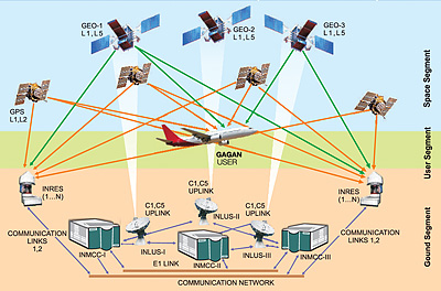
Global positioning System (GPS)-aided geo augmentation navigation (GAGAN), a navigation payload onboard the Indian Space Research Organisation’s (ISRO) geostationary satellite GSAT4, is the Indian satellite-based augmentation system (SBAS). It will plot a course to improve upon the accuracy of existing global navigation satellite system (GNSS) and overcome the limitations of traditional terrain-based radio systems for navigation of aircraft. GAGAN offers more than just reception of aeronautical data signals by an approved airborne SBAS receiver. For the operators of aircraft and air traffic management (ATM) services offered by Airports Authority of India (AAI), it would provide a safer and more efficient operating environment. Direct routing, accommodation of a larger number of aircraft in a given volume of airspace, reduced operational costs, higher levels of air safety and improved on-time performance of airlines are the benefits that would accrue from GAGAN to the aviation industry in India as a whole.
GAGAN is an integrated part of roadmap charted by AAI to modernise communication, navigation, surveillance and air traffic management (CNS/ATM) services. Currently, in its final phase of implementation, GAGAN is expected to be commissioned in 2013. Conceived in 2000, the project is a combined endeavour between the AAI and ISRO. The primary objective of GAGAN is to offer error-free aeronautical signals for accurate air navigation by aircraft while operating through Indian air space. With the help of GAGAN, India will be one among the few countries to have an indigenous SBAS.
Satellite-Based Navigation Systems
Navigation aids for aircraft have evolved from the simple magnetic compass of yesteryears to the modern day GNSS such as the American GPS. Other similar navigation systems under development are the Russian GLObal’naya NAvigatsionnaya Sputnikovaya Sistema (GLONASS), the European Union’s Galileo, which is a GNSS and the Chinese compass navigation system. However, measurements of velocity, position and time through satellite-based systems such as the GPS, which is currently the most widely used facility for air navigation, are influenced by satellite fix, signal propagation, and receiver errors. But more often than not, signals from GPS satellites fail to provide accurate measurements in safety-critical situations such as air navigation, especially over the equator and the tropics. This is due to the errors that creep in during the transit of signals through the ionosphere. This is a region in space that begins roughly at 50 km above the surface of the earth and extends up to over 600 km. Errors are usually rectified by augmentation—enhancement by either a terrain or space-based overlay system. GAGAN is a concept that aims to achieve this. The system meets the four primary navigation specifications; integrity, accuracy, availability and reliability of error-free signals for all phases of flight within the area covered by the GAGAN system. Airline and other operators will not only have to ensure that aircraft are appropriately equipped but also that pilots are ready to adopt the satellite based area navigation (RNAV). These issues are not yet covered by the regulatory regimes and hence currently are not binding on operators.
The need for satellite-based augmentation system in India was conceived as early as 2000 as part of future air navigation system (FANS) of the International Civil Aviation Organisation (ICAO). A number of countries possess an operational SBAS. These include the United States with its wide area augmentation system (WAAS) that was commissioned by the Federal Aviation Administration in 2003, Japan with its multi-functional satellite augmentation system (MSAS) has been around since 2007, and Europe with the European geostationary navigation overlay service (EGNOS), which was commissioned in October 2009.
Signals of current radio navigation aids such as the ILS, VOR and NDBs have certain limitations. Besides overcoming these limitations, GAGAN improves flight safety in all phases of flight while providing other benefits in terms of efficiency and capacity. Instrument landing system is ineffective beyond 35 miles from the runway threshold for an ILS approach, while VOR reception is not available beyond 250 miles or so if the aircraft is flying at higher altitudes. For flights over the Bay of Bengal and the Arabian Sea, it is difficult for ground controllers to monitor and for pilots to navigate, especially in bad weather. Voice communication is over high frequency band or text-based communication through CPDLC. Signals from GNSS systems are prone to ionosphere, troposphere, multi-path and receiver errors that may compromise safety of flight as measurements may not be accurate. GAGAN offers to resolve first of the two problems as multi-path and receiver errors are the functions of software and hardware integrity.
SP's AirBuz - CURRENT ISSUE