

UAV's - In Civil Service
Although military UAVs perform reconnaissance, surveillance and attack missions for military purposes, these are also being utilised in a small but growing number of civil applications, such as fire-fighting and research.
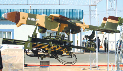
An unmanned aerial vehicle (uav), earlier referred to as a remotely piloted vehicle, is essentially an aircraft that flies without a human crew. Powered by a jet or reciprocating engine, it is a reusable machine capable of controlled and sustained level flight. UAVs have primarily been used in military applications. Although military UAVs perform reconnaissance, surveillance and attack missions for military purposes, they are also being utilised in a small but growing number of civil applications such as fire-fighting and research. In short, UAVs are often preferred for missions that are considered too “dull, dirty, or dangerous” for manned aircraft.
According to reports, the global market for UAVs is anticipated to reach a value of $13 billion to $15 billion (59,975 crore to 69,200 crore) by 2014. The market continues to grow albeit almost entirely in the military segment. However, with the backing of governments in Europe and the US, manufacturers of UAVs are now discovering a niche market for civil applications as well. There is progressive enlargement of all types of applications and missions in the non-military regime. Some of the payload capabilities used exclusively for the military thus far are now finding peacetime applications as well.
In India, it is time attention is focused in this direction to ensure production, hardware and software capabilities are reconfigured to meet the demand for UAVs in the civil segment given that the capabilities available indigenously are on a par with those flaunted by the western manufacturers. At present, there is no focus on this aspect. However, there is an imperative need to draw up a road map jointly by all the stakeholders, including the policy makers in the government, the armed forces and private entrepreneurs, for the exploitation of the unique attributes of UAVs in the civil sector.
So what can be the civil application of UAVs in India? Both government and private organisations engaged in homeland security, planning, materials and land information management, atmospheric observations, disaster management and development activities can utilise low cost UAVs to achieve the respective objectives of their missions.
Homeland Security
Use of UAVs for internal security can be divided into two broad categories, namely, domestic surveillance and crowd control. For the purposes of surveillance, UAVs have been used with mixed results, particularly for monitoring and countering insurgency and terrorist activities in India. State law enforcement agencies can utilise UAVs for crowd control and carry out activities for surveillance, garnering evidence or deployment of non-lethal payloads such as leaflets.
Seeker, a tactical UAV system, is reportedly already in use in South Africa for the purposes of monitoring crowds and carrying out urban surveillance activities. UAVs can also be used for patrolling, surveillance, security as well as traffic monitoring.
Materials Management
Periodic surveillance of high tension power lines, gas and sewage pipelines, roads, railway tracks and tracking of vehicles in real time is one area in which UAVs can enhance the quality of management.
In February, Bangalore-based Aerobat Unmanned Systems Private Limited announced it had been awarded a multi-million dollar contract by Ramelex Private Limited to use Helibot UAVs for monitoring power transmission lines in India, the Middle East and South East Asia. A payload of infra-red thermo vision camera will detect temperature anomalies of power lines and initiate reports.
Land Information Management
Land management is the process of managing the use and development of land resources in a sustainable way. Information about land needs to be carefully managed to maximise potential benefits. In the last two decades, new capabilities for data collection and processing, together with expanding requirements of users, have directed attention to the need for improved land information management strategies. The function of land information management in urban, rural and remote locations can and is being executed by the intelligent use of UAVs. Related areas where UAVs may be effectively utilised are habitat conservation, Land Allocation Decision Support System, Land Analysis Lab, sustainable agriculture and urban planning.
UAVs can be deployed in the agricultural tracts of Punjab, Haryana and Uttar Pradesh for several functions such as crop spraying and to monitor the spread of crop diseases. Yet another area of land management is in remote sensing. UAVs are more cost effective to operate than the satellites. Obtaining data from satellites may be expensive, tedious and time consuming. Some of the limitations of remote sensing by satellites can be overcome by UAVs flying at relatively low altitudes and providing high-resolution images. Private civil engineering firms are known to use geographic data obtained from remote sensing. Thus, there exists a potential market in this area.
Even in the management of forests UAVs throw up a number of advantages. One of the primary stakeholders in this case will be the Ministry of Environment and Forests. UAVs can be used to obtain data on wildlife population count, habitat change, migration patterns, monitoring of forest fires, changes in forest cover, encroachment and the telemetric tracking of radio tagged animals and birds. UAVs can be employed to control forest fires by dispensing fire retardants from larger platforms.
SP's AirBuz - CURRENT ISSUE